In high mountain regions, a number of natural catastrophes are related to glaciers, eg, outbursts of glacier-dammed lakes or interglacial water reservoirs, glaciers destroyed by volcanic eruptions, and various types of glacier surges. But the glacier catastrophe in 2002 in the North Caucasus was a rare phenomenon resulting from a combination of a glacier surge and a high-speed ice-water-stone mudflow. The latter's scale and particular nature makes it a unique phenomenon worldwide.
The surging Kolka Glacier
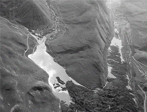
On 20 September 2002, a huge natural catastrophe destroyed the Genaldon valley in the Russian Republic of North Ossetia. Enormous masses of ice mixed with water and stone broke loose and rushed down the valley with high velocity, devastating everything along the way and stripping the slopes of forest and loose sediments up to a height of over 100 m. The avalanche was stopped by the Skalistyi mountain range, which runs perpendicular to the valley, but glacial debris flow burst through and brought ruin for the next 17 km. This occurred late in the evening. The next morning, the view of the path of destruction was stunning (Figure 1). The whole floor of the Karmadon depression was buried under a mass of scree 4 km long and up to 130 m deep. The ice also penetrated through the entrance of the narrow Skalistyi Gorge, thus blocking off both entrances of a tunnel on the main road. The village of Nizhnii Karmadon was completely destroyed and several rest homes along the Genaldon river below the gorge were devastated. Over 100 people were killed.
The catastrophe was caused by the surging Kolka Glacier located in the Kazbek massif and known for its repeated surges. Surging glaciers distinguish themselves from other glaciers through their instability, which results from their structure, especially their morphology and the characteristics of glacier feeding and ice discharge.
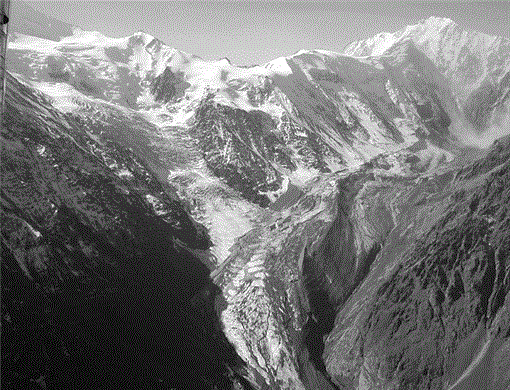
The Kolka Glacier is situated at the head of the Genaldon river (Terek basin). Figure 2 shows its confluence with the Maili Glacier in the west, one of the largest glaciers in North Ossetia. The Maili abruptly moves down from firn fields on the Kazbek, forming a thick icefall midway. During its quiet periods, the Kolka Glacier is about 3100 m long and covers 2.5 km2. The tongue lies at about 3000 m and the rear part goes up to 3450 m. The glacier accumulation is asymmetric. Its southern rocky slope (on the right) is steep, and from a ridge at 4000–4500 m, crevassed firn fields and hanging glaciers move down. Continuously occurring snow avalanches and ice falls feed the Kolka Glacier, ripping fragment material along that covers the gently slanting surface of the glacier. This thick morainic layer prevents the ice from melting. The northern (left) edge of the glacier is bordered by a high morainic terrace that plays an important role in the glacier's life, as it blocks the outflow of the ice coming from the south. The massive tongue of passive ice presses against this barrier, after which there is an abrupt turn of the streamlines and a relatively narrow exit. The permanent damming of the ice, accumulation of surplus ice and stone masses, and increasing tension from moving forces result in surges.
As a rule, surging glaciers situated in relatively gently sloping valleys like the Kolka Glacier progress gradually, with a velocity of several tens or hundreds of meters per day. The surface breaks into blocks and the tongue moves down a valley over several kilometers. Only when glaciers surge from steep slopes can their tongues be torn off, consequently collapsing as rockfall or mudflow.
Former surges
The Kolka Glacier has been through various scenarios. In 1902, the surge started with a typical advance of the glacier tongue during May–June and ended on 3 July in a catastrophic outburst of ice and water similar to the one in 2002, but on a slightly smaller scale. In a few minutes, the ice spread over 9 km through the valley and destroyed the aul (village) of Tmenikau high up on the slope. The ice dammed the river, but the water eventually broke through, creating a mudflow. This catastrophe occurred at the height of a hot summer and after heavy showers (Shteber 1903). A great volume of water had accumulated inside and under the glacier. According to eye-witnesses, the flow reached 60–70 km/h, and on a short section of the break itself it possibly exceeded 100 km/h. In 1902, the total volume of the material moved was estimated at 100–110 million m3.
It is obvious that similar catastrophes happened here in the past. While investigating the geomorphology of the Genaldon valley in the 1970s, we found clear traces of one more glacier surge much older and more massive than that of 1902: the outburst blocked the valley in front of the river outflow into the Karmadon depression, and a heavy mudflow ensued when this dam was broken. In the 19th century literature, a glacier surge is mentioned as happening around 1835 (Pastukhov 1889). Remarkably, unlike in many other valleys of the Caucasus, all old auls in the Karmadon valley are not situated on the valley floor—the most comfortable place for living—but on slopes and ridges. Apparently, the population has known about the threat of local glacier catastrophes for a long time.
Another surge occurred according to the “classic” scheme with a quieter process during the winter of 1969/70, when the basin had almost no meltwater. Active, sometimes slower advances continued from September to early January. For the whole period, the average velocity was 20–50 m/day, with peaks of over 200 m/day. The glacier's length thus increased by 4 km and descended the valley by 800 m (to 1975 m asl). The volume of dislocated ice was about 80 million m3.
An attempt to predict surges
From 1969 to 1978, the Institute of Geography of the USSR Academy of Sciences carried out observations of the Kolka Glacier both during and after the surge (Rototaev et al 1983). It was calculated that from 1950 to 1960, ie before the 1969 surge, the permanent positive mass balance of the Kolka Glacier produced an annual increment of 1–1.3 million tons. It was predicted that given constant climatic conditions and no anomalous external impacts, accumulation would continue for 60–70 years before attaining a critical level when discharge would be inevitable. Indeed, intervals between the known surges of the Kolka Glacier amounted to about 67 years.
In the 1990s, no special observations of the glacier were carried out. An analysis of aerial photographs made in 1958, 1972, 1981 and 1987 demonstrated that the process of increasing glacier volume advanced approximately at the same rate as predicted. On the space image made 38 days before the 2002 event, one can see that the glacier was not yet ready for a surge: the surface of the tongue was not high enough, no crevasse was to be seen, and the glacier end was hidden under the moraine. Unfortunately, this picture does not show the upper part of the glacier, which played an important role in the event.
The 2002 event
The catastrophe of 2002 was unexpected, as it occurred only 30 years after the previous surge. Changed external conditions must have accelerated the process. In 1983, K.P. Rototaev warned:
Under contemporary conditions, a turbulent-viscous glacial mudflow with significant water content, similar to the 1902 outburst, may possibly reach the exit of the Karmadon depression. Such a mudflow might tear off masses from the main glacier and discharge water accumulated behind this mass…. A mudflow of a turbulent, liquid and more rapid type could even reach the Skalistyi Ridge, penetrate the gorge and create large dams. Such a mudflow may produce waves up the slopes at the valley turns, thus enriching itself greatly with detrital rock material from the slopes and valley floor, and finally turning into a highly active mixed mudflow. Such a flow would discharge itself violently within the boundaries of the Karmadon depression, partly on the Skalistyi Ridge and especially on its Gizel part. (Rototaev et al 1983)
The glacier catastrophe on 20 September 2002 had exactly this scale and followed precisely this scenario.
Possible causes of the 2002 surge
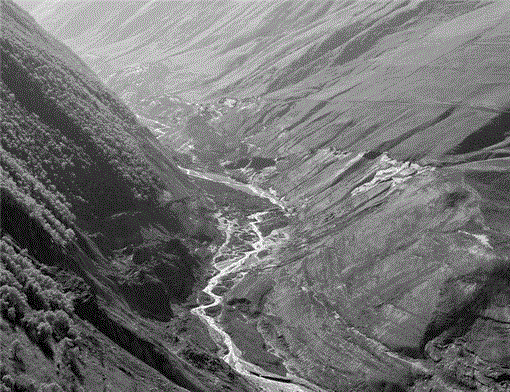
The destructive mudflow raced down the valley at a speed of 180 km/h and threw itself against the Skalistyi Ridge. From the head of the Kolka Gorge down to the Karmadon depression, loose deposits were torn off the slopes in typical waves up to a height of 140 m (Figure 3). The volume that filled the Karmadon depression (see Figure 1) was estimated at 110–120 million m3. Several lakes were formed—a sign that the mass was saturated with water. In a side valley close to the aul of Saniba, a lake appeared whose level rose threateningly for about a month after the glacier outburst, until a runoff path formed through inner channels in the ice body.
Uniqueness of the event
The most unexpected phenomenon was seen in the circus of the Kolka Glacier: the glacier had left its bed completely, revealing the bare rock bed. This meant that it had “left” with great velocity, ie, it must have virtually flown out onto the Maili Glacier, whose tongue turned out to be almost undamaged. Nothing similar has been observed anywhere in the world, especially with a glacier that was not a hanging glacier and whose surface inclination was only about 7–9° (Figure 4).
Seismic activity
Many scientists' first version of the tragedy was that it was caused by a massive icefall onto the rear right (southern) side of the Kolka Glacier. An ice scarp and the disappearance of the firn ice fields under the ridge (with a total estimated volume of 3–8 million m3) were indeed determined by investigators from the Russian Ministry of Extreme Events (MEE) during their first aerial survey after the surge. The opinion was voiced that an earthquake could have provoked this fall. But the Regional Seismic Service had recorded no earthquake in the region during the days preceding the event. Significant earthquakes were registered here earlier: one on 14 July (magnitude of 5, epicenter 11 km away), and the second on 22 August (magnitude of 3.5, epicenter 70 km away).
From 28 August to 4 September, a group of mountaineers also observed continuous rock and ice falls in this part of the Kolka Glacier circus, and described the slope as actually changing before their eyes. Photos show that the line of the ice scarp determined by MEE specialists 3 weeks later was almost completely formed. Another tourist group still noted active destruction of this slope at the end of June. It is possible that the falls were first provoked by the earthquakes and the ice scarp on the ridge not formed at one time only. The quakes certainly played a role in preparing the surge, as the mass of falling material significantly increased the load on the glacier. According to the mountaineers, by the beginning of September the surface of the glacier had already risen at the rear up to the edge of the morainic terrace on the left.
Climatic conditions
From the very beginning, we thought it absolutely evident that such an impetuous outburst of the glacier could only have occurred if a particularly large volume of water had accumulated under the glacier, due to anomalous melting of ice and snow in the high-altitude zone of the whole Caucasus area during the previous 4 years. Indeed, the reference Garabashi Glacier on the south slope of the Elbrus lost a 4-times greater mass in 3 years (1998–2001) than it had accumulated during the previous 14 years. The summer of 2002 was especially rainy on the North Caucasus. As a result, a great amount of water must have accumulated in and under the Kolka Glacier.
The calculations made to this purpose proved the importance of the climate factor as one of the causes for the premature surge of the Kolka Glacier. A 100-year series of annual average summer air temperatures on the glacier were retrieved from the closest meteorological stations, and melting of the glacier was calculated. From 1995 to 2002, the summer air temperatures were higher than average, and for the 4 years preceding 2002 glacier melting exceeded the norm by 1.5–2 times. Thus, the firn field located high above the right side of the glacier was included in the runoff. Very intensive melting may have played a role in the formation of the firn and ice falls.
Stinkdamp
Another extremely interesting phenomenon was observed: just after the glacier had left its bed, a strong smell of hydrogen sulfide (stinkdamp) occurred in the rear part of the empty bed. For many days, a cloud of vapor and gas hung over the circus. This and the fact that the slope nearby was continuously eroding, with local spots of ice and snow melting on the cold north wall as well (typical fumaroles, as volcanologists believed), were interpreted as volcanic manifestations of the Kazbek mountain massif. Indeed, the Upper Karmadon thermal springs, with a temperature up to 60°C, are situated not far from the end of the Maili Glacier. Therefore, one can hypothesize the existence of special thermal conditions under the glacier that may have initiated its melting from underneath, thus forming a water “cushion” on its bed. This would have accelerated the glacier surge. It should be noted that during the 9 years of monitoring in the 1970s, no signs of gas emission were observed.
Situation one year later
From June to October 2003, the Institute of Geography of the Russian Academy of Sciences (IGRAS) carried out the first field investigations and GPS surveys in the Kolka and Maili glacier circuses since the Karmadon catastrophe. Geomorphologic signs showed that a great quantity of water fell with the ice and stone mudflow. The character of the breaks on the sides of the valley and on the moraine ridge separating the glaciers indicate that a huge mass of water left from the right side of the Kolka Glacier, sweeping ice fragments over the Maili Glacier and onto the right slope above the Maili's tongue, leaving the hillsides on the right side of the Maili Glacier almost undamaged as the water washed over. This left the surface structure of the Maili Glacier almost unchanged, however with clear marks of the water flowing down (Figure 5). At the same time, the main mass of the ice and stone mudflow rushed along the normal way, ie, along the Kolka Gorge, splashing high up on the rocks on the left side of the gorge. Between these two flows, part of the moraine with vegetation remained undamaged.
A source of many questions was a rocky bar or riegel revealed on the bare surface of the glacier bed, behind which a lake was formed that constituted a potential threat in case the dam broke. It was believed that the riegel was the threshold of the bedrock, ie, a possible obstacle in the path of the glacier. Specialists even considered blasting it away to prevent future surges. It appeared later, however, that the riegel was a dam consisting of an ice core covered by large detrital material sloping steeply down the valley. The absolute height of its ridge is 3020–3060 m. We believe that the dam was formed by large and heavy remnants of the broken glacier that were blocked by the narrowing and sharp turn of the valley at this place. The increase in base inclination here caused a tearing off of the “tail” of the main mass of the mudflow.
In late June 2003, the lake covered an area of 150 × 50 m, having shrunk to approximately half the size it had been in autumn 2002. Its sides consisted of detrital material with ice outlets. The middle part of the dam rose to a height of only 10–15 m above the level of the lake. The water level decreased gradually, and by the end of September, the lake had disappeared without any catastrophic consequences.
The glacier bed was investigated. Its relief is irregular, and no bedrock is revealed. It is completely covered with different-size fragments. In some places one can see residues of the bottom of the ice mass. Of great interest is the origin of “ant heaps” spread over the whole surface of the glacier bed and partly consisting of ice pellets. The most active part is the downfall cone in the rear part of the circus. From June to August 2003, ice and stones were reported as continuously falling from the cliffs and from Mount Dzhimarai-Khokh. By the end of September, the falls stopped.
In the lower part of the empty right-hand side of the glacier are residues of older bottom ice, saturated with detrital material and traces of intensive erosive activity caused by surface water flows that penetrate the thick loose mass near the foot of the glacier. Photos taken immediately after the surge show a whole series of bars and grooves transversal to the total movement of the ice. Their direction, followed by streamlets of melted water, was not understood earlier on.
No gas smell was detected in the circus, but chemical analysis of the water and snow samples taken in June demonstrated that the sulphate-ion content of the water in the lake and the Kolka river was 400–600 times greater than the concentration measured in the firn basin on the slope.
Possible scenario of the 2002 event
Analysis of all data obtained allows conclusions about the causes and present a possible scenario of the event. The most important circumstance was the unusually unstable dynamics of the Kolka Glacier only 30 years after the previous surge. The premature surge of the glacier and huge scale of the catastrophe were provoked by a whole complex of factors. First, there was the accumulation of great quantities of water in and under the glacier, due to special climatic conditions. This water played the most important role. Another triggering factor was volcanic activity; apparently this caused additional melting of the bottom of the glacier and certainly favored unusually active falls from the right wall above the glacier. Additionally, ice and rock falls overloaded the rear part of the glacier and increased the tension in its body. However, contrary to what was initially hypothesized right after the catastrophe, the surge was not caused by a large one-off collapse from the higher firn fields. The tectonic structure of the region also played an important role: the Kolka valley is situated in a zone of large sub-latitudinal faults where displacements of individual blocks and earthquakes are highly probable.
A direct trigger for the glacier surge might have been just another minor fall, a small earthquake, or simply a destructive process inside the glacier that created a critical tension in its body. It is possible to suppose that the process began in the central part of the circus with a collapse of domes above internal cavities filled with water. The glacier violently pressed out part of the water from under itself, and this water, together with ice and small detrital fragments, flew over the right moraine onto the Maili Glacier, as well as over individual sections of the left moraine of the Kolka Glacier. The destruction of the main body of the glacier led to destruction of the support for the glacier's tributaries along the steep walls. In the lower part there was a break-off along crevasse zones. This added mass and energy to the initial motion of the glacier, which by then had lost its integrity. The direction of the movement along the bottom of the glacier can be reconstructed from a system of bars and grooves on residues of the old near-bottom ice oriented along the right slope. The major part of the ice mass rushed down along the main gorge of the Kolka river. These stages were in fact parts of a single rapid process that resulted in a total mass of water, ice and stone mudflow rushing down into the Genaldon valley with greatly increased velocity due to added impulse at the end of the Kolka Gorge, where the inclination exceeds 20°.
The future: no long-term rest
The Kolka Glacier will regain its volume over several decades. The scree and ice in the Karmadon depression will melt much more rapidly and become a stone and mud massif. Water will actively erode and make channels in the obstructing thickness. Inner falls and dams are highly probable—the source of new threatening mudflow floods. Monitoring of all these processes will be performed by surface, aerial and space services.
The past few years have been characterized by many catastrophic processes in the region. Weather anomalies were observed simultaneously in Russia, with the most significant extremes in the Northern Caucasus. In the summer of 2000, catastrophic mudflows occurred in the Baksan river basin. They partly destroyed the town of Tyrnyauz. In June 2002, extreme precipitation resulted in activation of landslides everywhere in the Northern Caucasus. This was also the case in August on the shores of the Black Sea. The Karmadon catastrophe in September concluded this black series.
In 1994, the All-Russian Institute of Engineering Geology (VSEGINGEO) made long-term forecasts of landslide and mudflow development in the Northern Caucasus until 2005. They anticipated activation of these phenomena due to anomalies in precipitation in 2002–2003 in the high mountain zone, in particular in North Ossetia (Kononova and Malneva 2003). Forecasts were made that took into account the characteristics of atmospheric circulation. At present, the occurrence of macro-processes with reduced pressure on the North Pole and accompanied by invading cyclones in the south, in particular in the Mediterranean region, is 4 times greater than the average. Most catastrophic landslides and mudflows are associated with these synchronous situations. A quick change of climate is impossible. Thus, it is highly probable that events similar to the natural process described here will occur in the next few decades.
REFERENCES
FIGURE 1
View of the Karmadon valley on the morning of 21 September 2002, the day after the natural catastrophe. Completely buried under the mass of ice, stone and water lies the village of Nizhnii Karmadon. (Photo courtesy of the Russian Ministry of Extreme Events, MEE)
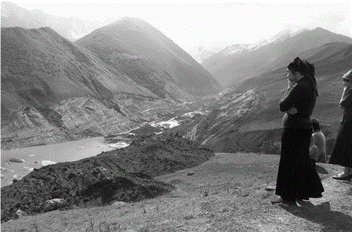
FIGURE 2
Photo taken from the International Space Station “Alpha” on 17 October 2002, by cosmonaut F. Yurchikhin. (Photo courtesy of NASA, see www.jsc.nasa.gov/images/eol/2002/kolka.html)
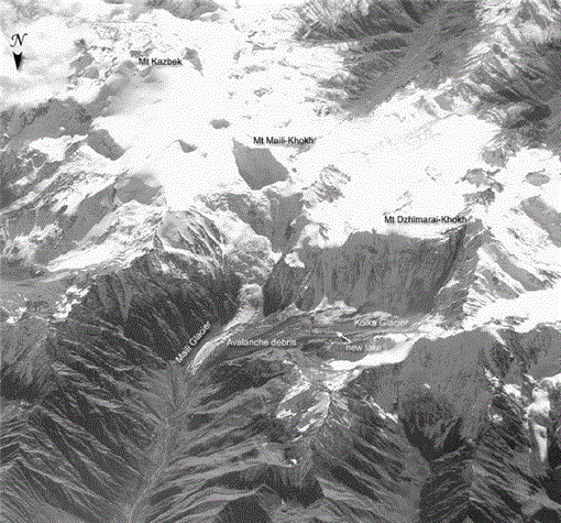
FIGURE 3
Traces of the “waves” left by the glacial debris flow on the slopes of the Genaldon valley. Some reach a height of 140 m. (Photo by N.I. Osokin)
